Hiking guides and maps in Martinique
Hiking in Martinique
Martinique attracts hikers with its biodiversity. Between tropical forests, wild beaches, volcanoes, and coastal trails, the island of flowers offers an infinite number of routes suitable for all levels. Whether you’re heading out with your family for an easy stroll or aiming for a challenging climb, hiking in Martinique promises a complete change of scenery, between sea and mountains, nature and culture.
Discover Martinique on foot
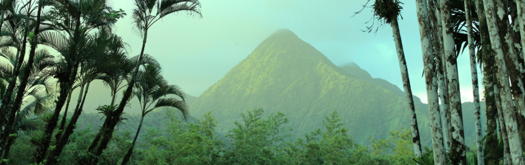
Located in the heart of the Lesser Antilles, the island of Martinique enjoys a pleasant tropical climate year-round. It is above all a land of contrasts: to the north, Mount Pelée and its vegetation; to the south, beaches lined with coconut trees and turquoise coves. The center of the island is full of rainforests, rivers, and waterfalls, ideal for hiking in Martinique.
In addition to its bountiful nature, the island boasts a rich cultural and historical heritage: ancient sugar cane plantations, the ruins of Château Dubuc, fishing villages like Sainte-Anne and Le Carbet, rum distilleries, and vibrant Creole traditions. Each hike becomes an immersion in an authentic culture and a preserved environment.
The most beautiful hiking trails in Martinique
- The Trace des Caps : The longest hike in Martinique, running along the entire southeast coast for approximately 30 km, from Petit Macabou to Anse Caritan. It is generally covered in four sections and offers views of deserted beaches, cliffs, coastal savannahs, and dry forests. Ideal for a multi-day hike.
- Montagne Pelée : A must-do for fans of athletic hikes, the ascent of Montagne Pelée peaks at 1,395 m. The most popular trail starts from the Aileron car park (Le Morne-Rouge). Allow 2 to 4 hours depending on your pace. A true Martinique Montagne Pelée hike with a 600-meter elevation gain and breathtaking views from the summit.
- La Caravelle Peninsula : A listed nature reserve, La Caravelle is perfect for a half-day outing. The trail runs along the sea, through mangroves, and up to the Caravelle lighthouse. This Caravelle Martinique hike is accessible and very popular, particularly for its spectacular views.
- The Beauregard Canal : Also known as the Slave Canal, this historic trail runs along a former irrigation canal built in the 18th century. Running along the mountainside, it passes through dense vegetation and offers a pleasant walk without much difficulty.
- The Didier and Saut Gendarme waterfalls : For a waterfall hike in Martinique, head to the heights of Fort-de-France or Fonds-Saint-Denis. These short walks lead to beautiful waterfalls in the middle of the rainforest, ideal for cooling off in a picture-postcard setting.
The essentials for hiking in Martinique
To fully enjoy hiking in Martinique and especially avoid poorly marked trails, here is an essential product to slip into your backpack:
- Martinique on foot : an FFRP hiking guide associated with IGN maps of the island with a selection of 35 walks and hikes suitable for all levels.
The hiking network in Martinique
Martinique has over 180 kilometers of marked trails spread across the island. The majority of these are referred to as “traces,” a local term that dates back to ancient paths used by hunters, gatherers, and escaped slaves. These trails are now protected by the Martinique Regional Natural Park, which works with local authorities to protect and maintain them.
The Martinique hiking network is very varied in difficulty :
- Easy hikes along the coast or to the waterfalls
- Intermediate trails through the hills and rainforests
- Challenging itineraries such as the climbs to Pelée, Morne Larcher, or Alma
Information panels and yellow markings are present on the main circuits, but some sections remain poorly maintained. It is therefore advisable to bring a map or guidebook for safe use.
So, has this made you want to discover the island of Martinique!