Hiking guides and maps on the GR®9
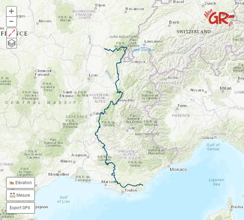
GR®9 – From the Jura to the Mediterranean
From the Haut-Jura Natural Park to the forests of the Var, the GR®9 crosses France from north to south, immersing you in varied and spectacular landscapes. It’s one of the wildest and most unknown trails in the GR® network. An ideal route for hiking enthusiasts seeking authenticity.
GR 9, a hike between mountains and the sea
The GR®9 connects Saint-Amour, in the Jura region, to Port-Grimaud, on the shores of the Mediterranean. Spanning nearly 1,000 kilometers, this long-distance hiking trail takes you through seven departments, from the Jura massif to the Mediterranean landscapes of the Var region.
It follows a north-south axis and passes through the Haut-Jura Regional Natural Park, with its deep forests and panoramic views of the ridges, the Bugey region and the banks of the Rhône around Culoz, the Chartreuse and Vercors massifs, then the arid landscapes of Drôme Provençale, and finally the Var region, between hills, scrubland, and coastline.
The GR®9 can be hiked in its entirety or in sections. The division into major stages allows for a flexible approach, adapted to the time available. To plan your route, it is recommended to refer to a GR 9 map or a FFRandonnée guidebook detailing the stages, accommodation, and points of interest.
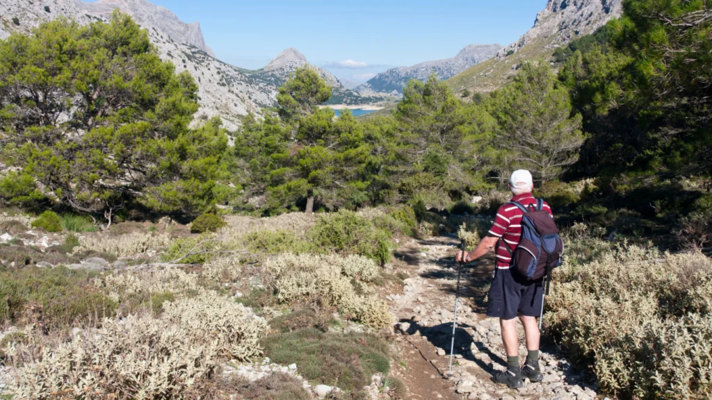
The white and red markings remain generally good, but some technical mountain passages require a good sense of direction. It is also advisable to check weather conditions, especially in spring and fall.
Long-distance hikers can plan between 45 and 60 days for the entire route. Most choose to start from north to south, gradually gaining a gentler foothold in the warmth of Provence and the Mediterranean coast.
The GR®9 is a wonderful alternative to overcrowded trails. Less well-known than other iconic GR® trails, it appeals to hikers seeking solitude, diverse landscapes, and a truly geographical and climatic journey.
The sites not to be missed on the GR®9
The GR®9 offers a unique journey through France’s great natural spaces. Its originality lies in the diversity of the landscapes it traverses, ranging from mid-mountain ranges to limestone plateaus, cliffs, forests, and the Var coastline.
For the Cartopedestre team, here are some key milestones:
- The Haut-Jura : wooded ridges, pastures, lakes, and typical villages
- The Chartreuse : a wild, steep-sided massif rich in biodiversity
- The Vercors : high plateaus, gorges, and spectacular balcony trails
- The Diois and Drôme Provençale : lavender fields, vineyards, hilltop villages
- The Massif des Maures : umbrella pines, cork oaks, and Mediterranean scents
- Le Port-Grimaud : a lakeside town a stone’s throw from Saint-Tropez, the final point on the Mediterranean
Some variants allow you to reach emblematic sites, such as the GR9 Mont Ventoux, which goes around or crosses the region of the giant of Provence.
Routes connected to the GR®9
The GR®9 crosses several other long-distance hiking trails, allowing you to create loops, extend your journey or alternate between mountain ranges.
- GR®51 – Balcony of the Mediterranean : runs along the coast between Marseille and Menton. It provides a perfect extension to the east after arriving at Port-Grimaud.
- GR®4 – From the Atlantic to Provence : a cross-country trail from west to east, starting from Royan on the Atlantic coast to Grasse in Provence, passing through iconic regions such as Limousin, Auvergne, and the Verdon Gorges.
- GR®59 – From the Vosges to the Jura : a route connecting the Vosges Mountains to the Jura, offering varied landscapes ranging from mountains to deep forests and lush green valleys, perfect for exploring eastern France.
These connections expand the possibilities, particularly for those who wish to extend their hike in the Jura or organize a hike to the calanques via the coastal paths.