Description
The National Map of Greenways and Cycle Routes in France
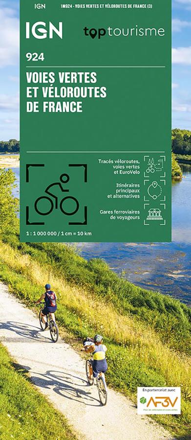
The IGN 924 Greenways and Cycle Routes of France map is an essential tool for planning a cycling trip. It allows you to see, at a glance, the major cycle routes that cross France.
It helps you choose a destination, identify connections between cycle routes, and plan a route based on your fitness level and available time.
Thanks to its 1:1,000,000 scale (1 cm = 10 km), this map provides a comprehensive overview of the French cycle network. It is not intended for following every street on the ground. However, it is perfect for planning an itinerary, comparing the main options, and organizing your trip before you set off.
Greenways, Cycle Routes, and EuroVelo Routes
This map lists the greenways, cycle routes, and major cycle routes in France. It particularly highlights the EuroVelo routes that cross the country.
It features well-known cycling routes such as La Vélodyssée, La Scandibérique, La Vélomaritime, La ViaRhôna, La Loire à Vélo, La Véloscénie, the Canal des 2 Mers à Vélo, and EuroVelo 6.
Furthermore, the map helps distinguish between different types of routes and provides a better understanding of what to expect. It's useful for identifying greenways, dedicated cycle routes, connections, and planned itineraries.
A practical tool for planning a cycling trip
This IGN map is particularly useful for cycle tourists, families, and travelers planning a weekend getaway, a multi-day tour, or a longer cycling holiday.
It allows you to identify major routes, choose a region, and create a coherent itinerary. To follow a specific stage, it can be supplemented with a guidebook or a more detailed map.
Finally, this map is an excellent starting point for discovering the cycling network in France. It simply inspires you to set off, connecting regions, valleys, canals, coastlines, and major cycling routes.
Map Highlights:
- National map of greenways and cycle routes in France
- Scale 1:1,000,000
- Equivalence: 1 cm = 10 km
- Produced in partnership with AF3V
- EuroVelo routes crossing France
- National, regional, and local cycle routes
- Greenways and major cycle routes
- Completed, partial, or planned routes
- Ideal for planning a cycling trip
- Very useful for choosing a destination or comparing several routes
- Practical map for an overview of the French cycling network
FAQ
What does the IGN 924 Greenways and Cycle Routes of France map show?
It presents the major cycle routes in France, including greenways, national and regional cycle routes, and EuroVelo routes.
Is this map suitable for planning a cycling trip?
Yes. It's ideal for choosing a destination, comparing major routes, and planning a cycling itinerary in France.
Can this map be used directly in the field?
It provides an excellent overview. However, its 1:1,000,000 scale is quite general. To follow a specific stage precisely, it's advisable to supplement it with a local map or a detailed guidebook.
What's the difference between a greenway and a cycle route?
A greenway is generally reserved for non-motorized travel. A cycle route can alternate between greenways, shared roads, and dedicated cycle paths. This map helps you better understand the network.
Does the map show EuroVelo routes?
Yes. It allows you to identify the major EuroVelo routes that cross France, such as La Vélodyssée, La Scandibérique, La Vélomaritime, La ViaRhôna or EuroVelo 6.
Features
Name
IGN Map - Greenways and Cycle Routes of France
Weight
0.1 kg
Language
French
pubication
2026
Publishers
IGN
Scale
1/1000 000