Description
A New Cycling Route Between the Loire and Garonne Rivers
La Véliberté is a cycling route conceived by Noël Itier. It connects the Loire River to the Garonne Lateral Canal, between Le Puy-en-Velay and Montauban.
This route offers a unique crossing of south-central France. It mostly follows roads with low traffic. It also includes sections on greenways, including more than 80 km on the Aveyron Valley and Gorges cycle route.
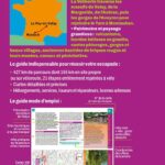
At 427 km, La Véliberté is aimed at cycle tourists looking for a different kind of route. The route crosses distinctive landscapes, from plateaus and valleys to gorges, villages, and unspoiled scenery.
From Velay to the Aveyron Gorges
The journey begins in Le Puy-en-Velay, an iconic city in the Haute-Loire region. The route then crosses the Velay, Margeride, and Aubrac mountain ranges.
Then, the route joins the Aveyron gorges. This section offers a beautiful mix of wild nature, rural heritage, and quiet roads. Finally, the route reaches the Tarn River at Montauban, before joining the Garonne Lateral Canal.
Moreover, the Véliberté route allows you to discover inland France, less frequented than the major cycling routes. It is therefore an ideal guide for cyclists seeking peace, authenticity, and freedom.
A practical guide to planning your trip
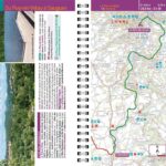
This Chamina guide offers 21 fully mapped stages for cycling. It allows you to plan your route according to your ability, pace, and available time.
You will find an overview of the regions crossed. The guide also details points of interest, recommended places to eat, accommodations, restaurants, bike repair shops, and useful services.
In addition, the train + bike information makes planning your departure and return easier. The 1:100,000 scale IGN (French National Geographic Institute) maps make it easy to follow the route and find your way.
Finally, the guide's compact size is practical for travel. It slips easily into a pannier, map case, or backpack.
About the author
Noël Itier is very familiar with hiking and cycling routes. He worked for many years at Chamina Édition, scouting routes on foot and by bike.
Now an independent author, he brings his cartography expertise and passion for nature to this new itinerary.
With La Véliberté, he offers a personal route, designed for cyclists who like to venture off the beaten path.
Guide Highlights:
- New Chamina Cycling Guide
- La Véliberté Route, from Le Puy-en-Velay to Montauban
- 427 km of cycling
- 21 fully marked stages for cycling
- Low-traffic roads and sections on greenways
- Over 80 km on the Aveyron Valley and Gorges cycle route
- Crossing the Velay, Margeride, Aubrac, and Aveyron Gorges regions
- Recommended addresses, accommodations, and cycling services
- Practical information: restaurants, repair shops, safety, access
- Train + cycling information
- Map based on IGN 1:100,000 scale maps
- Compact format fits easily in a pannier
FAQ
What route does the La Véliberté guide cover?
This guide covers the La Véliberté route, from Le Puy-en-Velay to Montauban. The route connects the Loire River to the Garonne Lateral Canal.
How long is the Véliberté cycle route?
The Véliberté is approximately 427 km long. The guide breaks it down into 21 stages, all of which are marked for cycling.
Is this guide suitable for a multi-day cycling trip?
Yes. It is designed to help you plan a multi-day cycling trip. The stages, maps, accommodations, and practical information help you organize your trip.
Does the route use greenways?
Yes. The route mainly follows roads with low traffic. It also includes sections on greenways, including more than 80 km on the Aveyron Valley and Gorges cycle route.
Does the guide include maps?
Yes. It features maps based on IGN (French National Geographic Institute) maps at a scale of 1:100,000. This allows you to visualize the stages, roads, and key landmarks along the route.
Features
Name
Cycling Guide to La Véliberté – From Le Puy-en-Velay to Montauban
Width
11.7 cm
Height
21 cm
Weight
0.13 kg
Language
French
pubication
2026
Scale
1/100 000