
Description
IGN Map Pyrenees Orientales
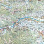
The TOP 100 series returns with a complete revision including an updated departmental breakdown. With its new scale of 1:100,000 (1 cm = 1 km), the TOP 100 offers the perfect map for exploring a region and practicing tourism on foot (GR), by bike or by car. The cycle routes are specially designed in partnership with the AF3V association - VéloRoutes et Voies Vertes, guaranteeing a safe and enriching experience.
This map includes points of interest such as:
- Historical and cultural heritage,
- Outdoor activities: climbing, hang gliding, reserve, park and garden
- Accommodation: Refuges, campsites, lodges
GRs and their variants:
- GRT83
- GR10
- GR36
- GRE4
- GRP
- GR107C
Features :
- Edition: 2024
- Language: French, English, German
- Single-sided printing
- Dimensions: 25 x 11.1 cm
- Flat dimension: 121 x 100 cm
- scale: 1/100,000
- Weight: 0.100 kg
- Publisher: IGN
Features
Name
Eastern Pyrenees - IGN 100 - D66
Width
11 cm
Height
25 cm
Weight
01 kg
Language
French
Publishers
IGN