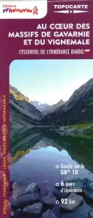
Description
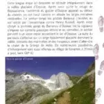
Hiking in the Gavarnie and Vignemale massifs
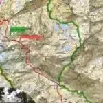
This topomap is based on the GR® 10 route and offers a 6-day loop to see major sites such as the Pont d'Espagne, Lake Gaube, the north face of Vignemale and Gavarnie.
An all-in-one product to experience roaming with complete peace of mind. Breakdown of the stages for the day, assets of the region crossed, precise IGN mapping, GPS tracks to download, accommodation... All the information necessary for the itinerant hiker is specified on this solid and flexible double-sided topomap.
You will find on this map:
- Loop on the GR1011 days of hiking
- 6 days of roaming
- 92 km of route on IGN background
- Accommodation, restaurants, transport
- Access to the GPX track
- Predefined and pre-cut steps
- Points of interest along the route
Features :
- Edition: 2024
- French language
- Flat dimensions: 136.8 x 100 cm
- Folded dimensions: 25.20 x 10.80 cm
- Printing: Double-sided, resistant to rain, snags, solid and flexible
- scale: 1/30,000
- Weight: 0.050 kg
- Publisher: FFRP
Made in France
Features
Name
FFRP map - In the heart of the Gavarnie and Vignemale massifs
Length
25.20 cm
Width
18.00 cm
Height
0.50 cm
Weight
0.50 kg
Language
French
Publishers
FFRP