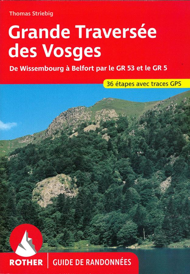
Description
A guide to hiking the Great Vosges Crossing
The Great Vosges Crossing is one of the major hiking routes in northeastern France. It follows the GR®53 and GR®5 trails, from Wissembourg to Belfort, through the Alsatian Vosges and the Vosges Mountains.
This Rother guide accompanies hikers on a long, varied, and scenic route. The itinerary crosses deep forests, charming villages, castles, mountain passes, ridges, and offers breathtaking viewpoints.
This guide is intended for hikers planning a complete trek. However, it can also be used to organize just a section of the route, over a few days or a long weekend.
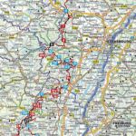
From the Northern Vosges to the outskirts of Belfort
The route begins in Wissembourg, in northern Alsace. It first crosses the Northern Vosges, with its forests, sandstone cliffs, and castle ruins.
Next, the route enters the central Vosges Mountains. The landscapes become more open. Ridges, high-altitude pastures, lakes, and panoramic views over the Alsace plain punctuate the hike.
Finally, the trail continues south through the massif, all the way to Belfort. This trek allows you to discover the full diversity of the Vosges, from north to south.
A practical guide to prepare each stage
This Rother guide offers reliable and detailed descriptions of the route. It helps you follow the trail, anticipate distances, and better assess the challenges.
In addition, hiking maps and elevation profiles allow you to visualize each stage. GPS tracks also complement the guide to facilitate navigation on the trail.
In practice, it's a useful resource for long-distance hikers. It's also suitable for walkers who want to plan a gradual trek over several days.
Finally, its compact size makes it easy to carry in a backpack. This is a practical companion for discovering the Vosges Mountains on foot, exploring nature, heritage, and wide-open spaces.
Key features of the guide:
- Guide dedicated to the Great Vosges Crossing
- Route via the GR®53 and GR®5 trails
- Route from Wissembourg to Belfort
- Crossing the Alsatian Vosges and the Vosges Mountains
- Reliable and precise route descriptions
- Detailed 1:110,000 scale maps
- Elevation profiles to assess changes in elevation
- GPS tracks available
- Compact guide, practical for multi-day hikes
- Ideal for a long hike or a section of the route
- Publisher: Rother
FAQ
What route does this Rother guide cover?
This guide covers the Great Vosges Crossing, via the GR®53 and GR®5 trails, from Wissembourg to Belfort.
Is this guide suitable for multi-day hiking?
Yes. It is designed to help you plan a long, multi-day hike. It can also be used to hike just a section of the route.
Does the guidebook include maps?
Yes. It includes detailed 1:110,000 scale maps, useful for visualizing the route and planning your stages.
Are GPS tracks included?
Yes. GPS tracks are available, allowing you to complement the use of the printed guidebook in the field.
Can you hike the Great Vosges Crossing in stages?
Yes. The route can be completed in several stages. The guidebook allows you to choose sections according to your fitness level, available time, and preferences.
Features
Name
Rother Guide Great Crossing of the Vosges – GR®53 and GR®5
Weight
0.22 kg
Language
French
Publishers
Rother
Type
Guide