
Description
A detailed map for hiking in Tenerife
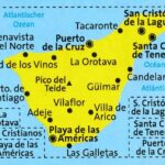
The Kompass Tenerife map is designed for hiking and outdoor enthusiasts. It covers the island of Tenerife in the Canary Islands, with precise mapping at a scale of 1:50,000.
This makes it easy to plan your routes before you set off. It also helps you find your way once you're there, whether you're going for a short walk, a more challenging hike, or a bike ride.
Thanks to its scale, the map offers excellent terrain information. It shows the terrain, contour lines, hiking trails, cycling routes, and key natural features.
A map suitable for hiking, cycling, and mountain biking
This Tenerife hiking map shows the trails with helpful information for assessing the routes. Furthermore, the routes can be categorized according to their level of difficulty.
Cyclists will also find cycling routes included. Mountain biking trails in Tenerife are also highlighted. This makes it a versatile map, useful for a variety of outdoor activities.
In addition, the map displays a wealth of tourist information. You can locate campsites, hostels, mountain huts, secluded hotels, sports facilities, leisure sites, and other points of interest.
A durable map for traveling in the Canary Islands
The map is printed on tear-resistant and weatherproof paper. It remains practical for use in the field, even in changing weather conditions.
Its folded size of 11 x 19 cm makes it easy to slip into a backpack. Furthermore, its double-sided printing allows you to cover the island without making the map too bulky.
Finally, this Kompass map is a great choice for planning an active trip to Tenerife. It's suitable for hikers, cyclists, backpackers, and nature lovers who want to explore the Canary Islands' landscapes with a reliable map.
Map Highlights:
- Hiking map dedicated to Tenerife
- Canary Islands, Spain
- Scale 1:50,000
- Double-sided printing
- Tear-resistant and weatherproof paper
- Hiking trails marked
- Cycling and mountain biking routes shown
- Contour lines for understanding the terrain
- Comprehensive tourist information
- Campsites, mountain huts, hostels, and isolated accommodations marked
- Legend in French, English, and German, 2019 edition
FAQ
Does this map cover the entire island of Tenerife?
Yes, this Kompass map is dedicated to Tenerife, in the Canary Islands. It allows you to plan hikes, bike rides, and sightseeing trips on the island.
Is this map suitable for hiking?
Yes. It shows hiking trails, contour lines, terrain features, vegetation types, and useful information for planning your routes.
Can this map be used for cycling or mountain biking?
Yes. The map shows cycle paths and also highlights mountain bike trails. It is therefore suitable for both hikers and cyclists.
Is the map durable?
Yes. It is printed on tear-resistant and weatherproof paper. This makes it practical for outdoor use.
Is the map in French?
The key is available in French, English, and German. However, the accompanying guidebook is in German.
Features
Name
Kompass Tenerife Map – Canary Islands, hiking and mountain biking
Weight
0.152 kg
Language
French English German
pubication
2019
Scale 1/50 000