
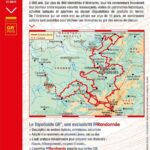
Description
The Great Vosges Escapes
Get this topoguide to go to the majestic Vosges on 3 GR country trails of 7 to 9 days including loops of 2 to 5 days.
You can admire grandiose landscapes combining mountains and forests and numerous rivers including the Vologne.
The blue line of the Vosges is a symbolic representation of the border behind which Alsace and part of Lorraine were once conquered by the Germans.
This hiking guide includes:
- IGN maps
- Marked routes in the field
- Walks classified by level of difficulty
- Essential practical information
- Photos to discover the region
Features :
- Edition: 2022
- French language
- Dimensions: 21 x 13.50 cm
- Number of pages: 128
- Weight: 0.210 kg
- Publisher: FFRP
Features
Name
Grandes échappées Vosgiennes sur les chemins de la ligne bleue
Length
13.50 cm
Height
21 cm
Weight
0.21 kg
Language
French
Type
Topoguide
This might interest you
Rother Guide Great Crossing of the Vosges – GR®53 and GR®5
Prepare for your hike on the Great Vosges Crossing with this Rother guide dedicated to the GR®53 and GR®5 trails. From Wissembourg to Belfort, the route traverses the Alsatian Vosges, its ridges, forests, villages, and sweeping panoramas. Detailed descriptions, maps, elevation profiles, and GPS tracks accompany hikers throughout the entire journey.
Jura, Franche Comté, des Vosges au Lac Léman, guide de randonnée
Guide de randonnée des Vosges au Lac Léman en Jura et Franche-Comté. 50 cartes de randonnée aux échelles 1/25 000 et 1/75 000 et 50 profils d'altitude ainsi que 2 cartes synoptiques.
L'échappée Jurassienne- itinéraire franco-suisse GR59-GR559-GR509-GR5
L'itinéraire franco-suisse de l'Echappée Jurassienne, vous traverserez le Jura d'Est en Ouest, dans une nature sauvage où se mêlent traditions, culture, gastronomie